
About Canadian UAVs
.webp)
Canadian UAVs is the only Remotely Piloted Aircraft System (RPAS) company to be given Beyond Visual Line of Sight (BVLOS) certification from Transport Canada. We are the only Operator allowed to fly at night and at a height of 800 feet above ground level, higher than other drone companies.

Manned Precision Specialists
We bring our manned aviation experience to the table, giving us the highest quality unmanned aviators and equipment ensuring unmatched precision, security and service.

Defence ISR Solutions
As a defence prime contractor with the Canadian Department of National Defence, we can provide unmanned intelligence, surveillance and reconnaissance (ISR) services and are bidders on the Royal Canadian Navy’s Intelligence, surveillance, target acquisition, and reconnaissance (ISTAR) program.
Company Profile
Canadian UAVs was founded in 2015 with the vision that Unmanned Aerial Vehicles (UAVs) (also known as Remotely Piloted Aircraft Systems (RPAS)) should be treated in the same way as traditional manned aircraft.
Today the company:
- Provides services and products related to RPAS operations, as well as RPAS Training services
- Comprises a team of professionals with extensive RPAS experience, providing a strong basis for safe operations and lifecycle control of RPAS equipment
- Operates only professional or military grade RPAS
- Operates its in-house developed Sparrowhawk™ Radar product, a ground-based radar system that provides a Detect and Avoid (DAA) capability, which enables Transport Canada permitted RPAS Beyond Visual Line of Sight (BVLOS) flight operations
Canadian UAVs is focused on ongoing integration and development of technology and processes to allow RPAS BVLOS operation to become routine. Compared to VLOS operations, BVLOS operations drastically improve the potential data captured by RPAS, as shown in the table:
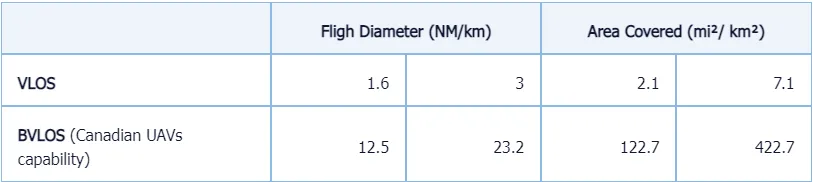
Flight Diameter (NM | km)
Area Covered (mi² | km²)
VLOS
1.6
3
2.1
7.1
BVLOS (Canadian UAVs capability)
12.5
23.2
122.7
422.7
Through our RPAS Operations services we acquire imagery and remote sensing data that serve public and private sector customers as follows:
- Pipelines (leak detection and inspection)
- Railways (infrastructure monitoring and vegetation analysis)
- Utilities (inspection/monitoring of power line clearances with respect to vegetation & objects and asset integrity monitoring)
- Oil & gas/Mining (terrain 3D imaging, site assessments, and inspections)
- Agriculture (crop analysis)
- Emergency response services (day and night)
- Environmental monitoring (water & air monitoring)
- Disaster Response (situational awareness and mapping)
- Forestry (forest fire monitoring/management)
- Policing (traffic and accident data collection)
- Security of critical infrastructure
- Military operations
Ready to fly?
Book a consultation with one of our UAV expert today and we can elevate your perspective