
Story of Sparrowhawk
DAA and Sparrowhawk
For years the holy grail of unmanned aerial vehicles has been detect and avoid technology. Said differently, a UAV needs to be able to assess its surroundings such that it can navigate safely in its environment. This problem, if solved, would represent the critical missing piece of innovation that’s been missing in civil unmanned aviation and would transform the way we move through the air. However the chicken and egg problem with DAA is that the UAV must become large enough to carry a functional detection sensor. While airborne radars have existed for fighter jets and transport craft, they are too large and expensive for small drones flying at hundreds of feet. Small aircraft can not carry such sensors. The UAV itself would expend all its payload on the DAA and thus not be useful for anything else. Insert Sparrowhawk.

Sparrowhawk was conceived in 2016 by Canadian UAVs’ CEO, Sean Greenwood. If you could not carry the DAA sensor on board, it would be best to place one on the ground and pair it intimately with the pilot. This wasn’t the perfect end-state, but it could extend your range to beyond visual line of sight (BVLOS) and create an exponential increase in area coverage. However, now insert problem #2. Ground based air traffic control radars are expensive. Like – really expensive. At the time, ground based radars were upwards of a million dollars, and came with no approvals for BVLOS. You not only had to find a radar that worked, but you had to demonstrate it worked to an unknown approval authority, through an undefined approval mechanism, and you had to find a pot of gold to pay for it.
A working radar, a long range commercial quality drone, a flight permit, an educated regulator, and highly trained people would all be needed to create a functional and economic BVLOS solution.
This set of problems became the genesis for Sparrowhawk and for Canadian UAVs as a whole. Our mission became:
To create the ecosystem for the integration of UAVs into complex airspace.
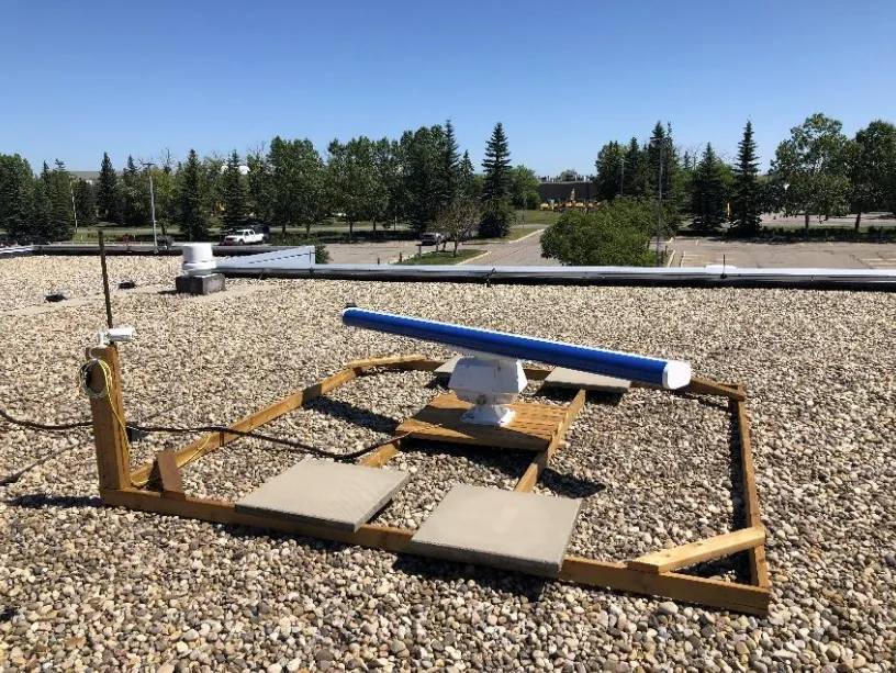
Plenty of radars existed on the market. Even radars with long range and high reliability. They were even affordable! However none were tuned to track aircraft. Sean and team chose to experiment with high power, certified, marine radar to see how well it could track small objects such as aircraft.

In 2018, Canadian UAVs worked with Transport Canada to demonstrate the feasibility of using marine radar to track small aircraft. As part of these trials Transport Canada observed that it was indeed possible, and this laid the groundwork to begin enabling automatic of target detection. But how?

Insert Eric Eidelberg – software developer and computer vision researcher from the University of Calgary. Eric felt the problem of extracting aircraft from traditional radar could be done using computer vision. A previously undiscovered technique, which emulated how a human would interpret radar imagery, could be used and would yield a much higher reliability that a human user. COMPUTER VISION AIRCRAFT DETECTION became a patented approach to utilizing 2D radar to track aircraft – filed in 2020.

Project SkySensus
In late 2019, Canadian UAVs joined project SkySensus - a consortium of companies led by a substantial investment by Arcfield Canada. This brought the funding needed to make Sparrowhawk a commercial reality. This 5-year funding stream, as part of the Canadian Industrial and Technological Benefits policy, provided the pathway to discovering the holy grail of UAV technology.


Innovation proceeded from 2019 through today to demonstrate the functional application of Sparrowhawk and generate the complete ecosystem for the integration of UAVs into any airspace. Many experiments were conducted, and we worked with many partners – Arcfield Canada, the Foremost UAS Test Range, Aerium Analytics, Ventus Geospatial, Radar Insight, the National Research Council, PrairiesCan, LookNorth and Tecterra, to name a few. The goal was always to find the most economical and effective way to conduct BVLOS activities.

We had to maintain the robust reliability of the marine radar, while adding in effective aircraft detection and tracking. Many experiments were conducted with the radar itself, with varying installation methods, beam modifications and ground clutter elimination.

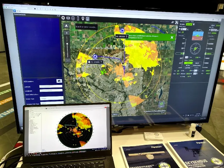
Extensive work was done by our software development team to not only extract fliers, but to model and predict the behaviour of radar tracks to learn what was a threat and what was not. Through a partnership with Lockheed Martin, we integrated our radar solution to their VCSi ground control station, creating a unified presentation of airspace when flying our aircraft.
Since its humble beginnings, Sparrowhawk has over 30,000 operational hours, tracking hundreds of thousands of aircraft. We have deployed across Canada and into the United States.

Algorithms have been refined and validated against an assortment of manned aircraft, and ADS-B truthing data. In 2020, Canadian UAVs received the first ever permit using Sparrowhawk as the primary means of DAA for operations in the Alberta oil-sands. As part of this mission, over 120 km2 was mapped from a single radar location.

Since 2020, Canadian UAVs and Project SkySensus has continued to invest in research and development related to Sparrowhawk and BVLOS, with Canadian UAVs now having a Canada wide delegation of authority for BVLOS with several different aircraft, a crew of pilots, and several Sparrowhawk installations – both fixed and mobile.
Sparrowhawk is now for sale internationally, supported by 7 years of research, tens of thousands of hours of use, and BVLOS permits that are the first of their kind in North America. It is priced in such a way as to be an enabler of BVLOS, rather than an impediment to it. Today, Canadian UAVs operates BVLOS routinely in Canada with installations planned for the USA and UK.
